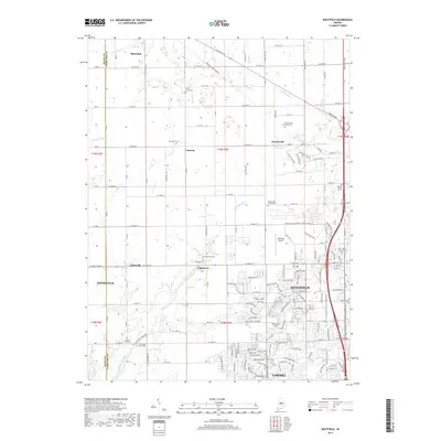
2019 Map of Westfield
USGS Topo · Published 2019About this map
Westfield serves as the focal point of this Hamilton County landscape, where modern suburban development meets a deep Quaker heritage. The presence of numerous historic burial grounds, such as the Anti-Slavery Friends Cem and Greenwood Friends Cem, points to the region's early settlement by the Society of Friends and their involvement in the abolitionist movement. The terrain is defined by the drainage of Little Eagle Cr and Cool Cr, which historically dictated the placement of small outlying communities like Hortonville, Eagletown, and Jolietville. While the southern reaches toward Carmel show a dense network of residential streets and the sprawling Chatham Hills golf course development, the northern portions preserve a more rectilinear agricultural grid. Of particular interest is the path of the Kinsey Ave E to Monon Trail and the proximity of the Westfield Airport, highlighting the transition from traditional rail corridors to contemporary transportation and leisure infrastructure.
Find a feature on this map
120 named features on this map. Tap any name to fly to it.
Don’t see what you’re looking for? This feature index may not catch every label — zoom into the map to look around manually.
Map Details
Editions of this 2019 Westfield Map
This is the sole edition of this map. No revisions or reprints were ever made.
Other maps of this area

1952 · Fishers
USGS Topo · 1:24,000

1952 · Carmel
USGS Topo · 1:24,000

1953 · Westfield
USGS Topo · 1:24,000

1953 · Rosston
USGS Topo · 1:24,000

1953 · Zionsville
USGS Topo · 1:24,000

1953 · Noblesville
USGS Topo · 1:24,000

1953 · Danville
USGS Topo · 1:250,000

1953 · Indianapolis
USGS Topo · 1:250,000

1955 · Danville
USGS Topo · 1:250,000

1956 · Danville
USGS Topo · 1:250,000