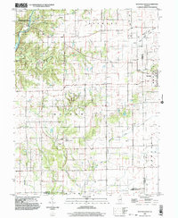
1998 Map of Westfield West
USGS Topo · Published 2003About this map
The Embarras River defines the western edge of this landscape, carving through the terrain just east of Charleston. This survey captures the rural boundary lands between Coles, Cumberland, and Clark counties, where agriculture and resource extraction intersect. The eastern portion of the quadrangle is marked by the Gas Fields Creek and several drilling operations, highlighting the area's history with the Illinois oil and gas industry.
Find a feature on this map
20 named features on this map. Tap any name to fly to it.
Don’t see what you’re looking for? This feature index may not catch every label — zoom into the map to look around manually.
Map Details
Editions of this 1998 Westfield West Map
This is the sole edition of this map. No revisions or reprints were ever made.
Other maps of this area

1933 · Toledo
USGS Topo · 1:62,500

1936 · Oakland
USGS Topo · 1:48,000

1936 · Casey
USGS Topo · 1:48,000

1938 · Toledo
USGS Topo · 1:62,500

1942 · Oakland
USGS Topo · 1:62,500

1942 · Casey
USGS Topo · 1:62,500

1943 · Casey
USGS Topo · 1:62,500

1946 · Kansas
USGS Topo · 1:62,500

1949 · Kansas
USGS Topo · 1:62,500

1953 · Indianapolis
USGS Topo · 1:250,000