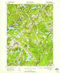
1950 Map of Westford
USGS Topo · Published 1958About this map
Stony Brook and the Boston and Maine Railroad define the industrial and residential corridors of this mid-century Middlesex County landscape. The map reveals the distinct village structure of the era, where established centers like Forge Village and Graniteville sit alongside newer developments at Nabnasset. The prevalence of granite quarrying and mill work is suggested by the rail stops and the dense cluster of family-named hills, such as Millstone Hill and Kissacook Hill. Genealogists will find significant detail in the multiple burial grounds, including the Russian Cem, Westlawn Cem, and Fairview Cem. Moving south toward Littleton Common and North Acton, the terrain softens into a network of large glacial bodies like Nagog Pond and Long Pond, reflecting a region balancing its industrial roots with growing suburban and recreational character.
Find a feature on this map
71 named features on this map. Tap any name to fly to it.
Don’t see what you’re looking for? This feature index may not catch every label — zoom into the map to look around manually.
Map Details
Editions of this 1950 Westford Map
4 editions found
Other maps of this area

1886 · Lowell
USGS Topo · 1:62,500

1886 · Framingham
USGS Topo · 1:62,500

1887 · Marlboro
USGS Topo · 1:62,500

1889 · Marlboro
USGS Topo · 1:62,500

1889 · Framingham
USGS Topo · 1:62,500

1893 · Lowell
USGS Topo · 1:62,500

1893 · Groton
USGS Topo · 1:62,500

1894 · Framingham
USGS Topo · 1:62,500

1896 · Marlboro
USGS Topo · 1:62,500

1898 · Marlboro
USGS Topo · 1:62,500