1942 Map of Westhampton
USGS Topo · Published 1942About this map
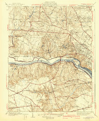
The James River corridor west of Richmond undergoes significant mid-century transition on this sheet, where the Kanawha Canal and the Chesapeake and Ohio Railway track the northern bank. On the southern shore, the Southern Railway serves established communities like Bon Air and Mt Nebo. Cultural landmarks are prominent, including the University of Richmond and the Bellona Arsenal (Ruins) further upstream near Lorraine.
Find a feature on this map
67 named features on this map. Tap any name to fly to it.
Don’t see what you’re looking for? This feature index may not catch every label — zoom into the map to look around manually.
Map Details
Editions of this 1942 Westhampton Map
2 editions found

Other maps of this area

1890 · Goochland
USGS Topo · 1:125,000

1892 · Goochland
USGS Topo · 1:125,000

1894 · Bermuda Hundred
USGS Topo · 1:62,500

1894 · Richmond
USGS Topo · 1:62,500

1895 · Richmond
USGS Topo · 1:62,500

1897 · Amelia
USGS Topo · 1:125,000

1934 · Richmond
USGS Topo · 1:24,000

1936 · Richmond West
USGS Topo · 1:24,000

1936 · Glen Allen
USGS Topo · 1:24,000

1938 · Drewrys Bluff
USGS Topo · 1:24,000