
1929 Map of Westhaven
USGS Topo · Published 1929About this map
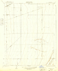
The boundary between Fresno Co Kings Co bisects this agricultural landscape, recorded during a period of significant infrastructure development in the Central Valley. Irrigation and utility networks dominate the terrain, notably the San Joaquin and Light Power Corporation lines that stretch across the quadrangle. Transport and water management define the local economy, with the Southern Pacific railroad serving the station at Westhaven Sta. To the southeast, the water systems of the Empire Canal and the Blakeley Wasteway illustrate the complex hydraulic engineering required for farming in this region. The grid of the land is further established by prominent thoroughfares such as Jamesan Avenue and Jayne Avenue, which provide the framework for the rural settlements of Westhaven and the nearby Henrietta Sub Station.
Find a feature on this map
11 named features on this map. Tap any name to fly to it.
Don’t see what you’re looking for? This feature index may not catch every label — zoom into the map to look around manually.
Map Details
Editions of this 1929 Westhaven Map
2 editions found
Other maps of this area

1912 · Coalinga
USGS Topo · 1:125,000

1926 · Lethent
USGS Topo · 1:31,680

1927 · Lemoore
USGS Topo · 1:31,680

1929 · Stratford
USGS Topo · 1:31,680

1930 · Discovery Well
USGS Topo · 1:31,680

1932 · West of Lethent
USGS Topo · 1:31,680

1933 · Kettleman City
USGS Topo · 1:31,680

1933 · Huron
USGS Topo · 1:31,680

1933 · Chatom Ranch
USGS Topo · 1:31,680
1934 · La Cima
USGS Topo · 1:31,680