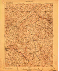
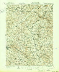
1905 Map of Westminster
USGS Topo · Published 1922About this map
Dug Hill Ridge forms a prominent natural spine through this early twentieth-century landscape, where the agricultural valleys of Carroll County, Maryland meet York County, Pennsylvania. The area is defined by a dense network of water-powered industry and rural settlements, with Grave Run Mills and Bachman Mills serving as vital local hubs. The Western Maryland R. R. cuts a path through the rolling hills, connecting established towns like Manchester and Hampstead to the broader regional economy. Small crossroads communities such as Lineboro, Wentz, and Melrose dot the landscape along the Harrisburg Road, reflecting a late-nineteenth-century pattern of settlement before the widespread adoption of modern highways. This survey provides a clear view of the numerous runs and creeks, including Gunpowder Falls and Codorus Cr., which dictated the placement of early homesteads and millsites.
Find a feature on this map
93 named features on this map. Tap any name to fly to it.
Don’t see what you’re looking for? This feature index may not catch every label — zoom into the map to look around manually.
Map Details
Editions of this 1905 Westminster Map
6 editions found
Other maps of this area

1892 · Ellicott
USGS Topo · 1:62,500

1893 · Frederick
USGS Topo · 1:125,000

1894 · Ellicott
USGS Topo · 1:62,500

1894 · Baltimore
USGS Topo · 1:62,500

1894 · Frederick
USGS Topo · 1:125,000

1899 · Baltimore
USGS Topo · 1:62,500

1900 · Parkton
USGS Topo · 1:62,500

1902 · Parkton
USGS Topo · 1:62,500

1904 · Baltimore
USGS Topo · 1:62,500

1905 · Westminster
USGS Topo · 1:62,500