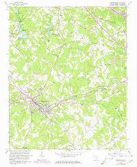
1963 Map of Westminster
USGS Topo · Published 1981About this map
Westminster serves as the focal point of this Oconee County landscape, where the Southern railroad line cuts through the Piedmont terrain. The map documents a rural society structured around crossroads and small-scale industry, evidenced by landmarks like Hicks Store and the Walhalla Filtration Plant. The rail-line's influence is clear, connecting the main town to outlying points like Clearmont, Richland, and the stop at Wrights Siding.
Find a feature on this map
53 named features on this map. Tap any name to fly to it.
Don’t see what you’re looking for? This feature index may not catch every label — zoom into the map to look around manually.
Map Details
Editions of this 1963 Westminster Map
2 editions found
Other maps of this area

1886 · Walhalla
USGS Topo · 1:125,000

1888 · Pickens
USGS Topo · 1:125,000

1892 · Walhalla
USGS Topo · 1:125,000

1894 · Pickens
USGS Topo · 1:125,000

1896 · Walhalla
USGS Topo · 1:125,000

1954 · Greenville
USGS Topo · 1:250,000

1958 · Greenville
USGS Topo · 1:250,000

1958 · Seneca
USGS Topo · 1:24,000

1958 · Fair Play
USGS Topo · 1:24,000
1959 · Walhalla
USGS Topo · 1:24,000