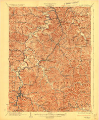
1926 Map of Weston
USGS Topo · Published 1926About this map
The West Fork River winds through Lewis and Harrison Counties, anchoring a landscape of small agricultural hubs and mountain valleys during the mid-1920s. Weston serves as the primary municipal center at the junction of Stonecoal Creek and Town Run, where the Baltimore and Ohio railroad corridor facilitates the regional economy. This survey documents a highly decentralized network of rural education and worship, with dozens of family and community-named institutions like Sycamore Dale School, Sheets Mill School, and Stonecoal Chapel scattered along the ridge-and-valley terrain. The map captures the infrastructure of the era before modern highway expansion, highlighting the significance of minor waterways and the placement of Jackson Mill and Jane Lew along the river's path. These details reflect the early 20th-century settlement patterns in the North Central West Virginia hills, where life was organized around the proximity of the railroad and the numerous creeks feeding into the West Fork.
Find a feature on this map
123 named features on this map. Tap any name to fly to it.
Don’t see what you’re looking for? This feature index may not catch every label — zoom into the map to look around manually.
Map Details
Editions of this 1926 Weston Map
4 editions found
Other maps of this area

1893 · Buckhannon
USGS Topo · 1:125,000

1893 · Sutton
USGS Topo · 1:125,000

1896 · Buckhannon
USGS Topo · 1:125,000

1897 · Buckhannon
USGS Topo · 1:125,000

1902 · Clarksburg
USGS Topo · 1:62,500

1902 · Fairmont
USGS Topo · 1:62,500

1904 · Philippi
USGS Topo · 1:62,500

1904 · Weston
USGS Topo · 1:62,500

1904 · Vadis
USGS Topo · 1:62,500

1905 · Centerpoint
USGS Topo · 1:62,500