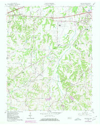
1959 Map of Westover
USGS Topo · Published 1980About this map
MC Kellar Field serves as a prominent landmark in this portion of Madison County, situated near the intersection of several significant local transit corridors. The landscape is defined by the drainage basins of Big Black Creek and Johnson Creek, which cut through the terrain south of the Louisville and Nashville Railroad. This era of the late 1950s shows a well-distributed network of rural institutions, including Upper Ingram Sch, Neely Sch, and Blairs Sch, alongside numerous community hubs like Andrews Chapel and Mt Olive Ch. The presence of Burkitt Siding and the Illinois Central Gulf Railroad highlights the ongoing importance of rail infrastructure for the small settlements of Denmark and Huntersville. Transportation is further anchored by historical routes such as the Steam Mill Ferry Road and America Road, reflecting the evolution of local travel from river-oriented ferries to modern highway systems.
Find a feature on this map
36 named features on this map. Tap any name to fly to it.
Don’t see what you’re looking for? This feature index may not catch every label — zoom into the map to look around manually.
Map Details
Editions of this 1959 Westover Map
3 editions found
Other maps of this area

1950 · Jackson South
USGS Topo · 1:24,000

1950 · Jackson North
USGS Topo · 1:24,000

1951 · Jackson North
USGS Topo · 1:24,000

1956 · Blytheville
USGS Topo · 1:250,000

1959 · Blytheville
USGS Topo · 1:250,000

1959 · Bells
USGS Topo · 1:24,000

1959 · Westover
USGS Topo · 1:24,000

1959 · Denmark
USGS Topo · 1:24,000

1959 · Adair
USGS Topo · 1:24,000

1961 · Medon
USGS Topo · 1:24,000