
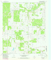
1966 Map of Westover SE
USGS Topo · Published 1968About this map
The Brazos River cuts through the northern reaches of this Throckmorton County landscape, defining a terrain shaped by water and petroleum. This mid-century environment is dominated by the energy industry, with the Lendra Oil Field and Travis Oil Field occupying significant portions of the northern survey area. Numerous scattered Oil Wells dot the grasslands, connected by an extensive Pipeline network that traverses the topography.
Find a feature on this map
13 named features on this map. Tap any name to fly to it.
Don’t see what you’re looking for? This feature index may not catch every label — zoom into the map to look around manually.
Map Details
Editions of this 1966 Westover SE Map
2 editions found
Other maps of this area

1954 · Wichita Falls
USGS Topo · 1:250,000

1958 · Wichita Falls
USGS Topo · 1:250,000

1963 · Megargel
USGS Topo · 1:24,000

1964 · Padgett
USGS Topo · 1:24,000

1965 · Throckmorton NE
USGS Topo · 1:24,000

1966 · Rock Canyon
USGS Topo · 1:24,000

1966 · Westover SW
USGS Topo · 1:24,000
1966 · Throckmorton
USGS Topo · 1:24,000
1966 · Westover
USGS Topo · 1:24,000
1966 · Proffitt Crossing
USGS Topo · 1:24,000