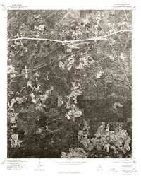
1975 Map of Westover
USGS Topo · Published 1977About this map
Westover and the surrounding Shelby County countryside are captured here in a 1975 aerial orthophotograph, providing a high-contrast look at the landscape during a period of transition. The imagery shows a clear division between the densely wooded ridges and the geometric patterns of cleared farmland and pasture. A prominent highway corridor bisects the upper third of the quadrangle, serving as the primary artery for the settlement of Westover. This specific type of survey, produced in cooperation with the Soil Conservation Service, emphasizes the surface texture of the earth, revealing the intricate drainage patterns and logging tracks that might be obscured on a traditional line-drawn topographic map. For local historians, it offers a distinct view of mid-1970s land use before the accelerating suburban development of later decades changed the character of the region.
Find a feature on this map
1 named feature on this map. Tap any name to fly to it.
Don’t see what you’re looking for? This feature index may not catch every label — zoom into the map to look around manually.
Map Details
Editions of this 1975 Westover Map
This is the sole edition of this map. No revisions or reprints were ever made.
Other maps of this area

1890 · Bessemer
USGS Topo · 1:125,000

1890 · Talladega
USGS Topo · 1:125,000

1892 · Talladega
USGS Topo · 1:125,000

1892 · Bessemer
USGS Topo · 1:125,000

1906 · Vandiver
USGS Topo · 1:62,500

1908 · Vandiver
USGS Topo · 1:62,500

1909 · Columbiana
USGS Topo · 1:62,500

1911 · Columbiana
USGS Topo · 1:62,500

1915 · Gantts Quarry
USGS Topo · 1:48,000

1917 · Gantts Quarry
USGS Topo · 1:62,500