
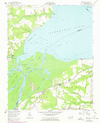
1954 Map of Westover
USGS Topo · Published 1957About this map
Albemarle Sound and the complex river delta where the Roanoke River meets Batchelor Bay dominate this mid-century coastal landscape. The survey documents a critical junction of transport and agriculture in the tidewater region, showing the convergence of the Norfolk Southern railway lines near the settlement of Roper. Along the shoreline, places like Albemarle Beach and Cashoke Landing reflect the water-dependent economy, while inland, the Tidewater Experiment Station points to the area's agricultural research significance. The map provides excellent genealogical detail through its placement of rural congregations and burial grounds, including Saints Delight Ch, White Marsh Ch, and St Luke Cem. Low-lying wetlands such as Morgan Swamp and Black Walnut Swamp weave between the established hamlets of Westover and Macedonia, illustrating the environmental constraints on coastal North Carolina development.
Find a feature on this map
40 named features on this map. Tap any name to fly to it.
Don’t see what you’re looking for? This feature index may not catch every label — zoom into the map to look around manually.
Map Details
Editions of this 1954 Westover Map
2 editions found
Other maps of this area

1904 · Edenton
USGS Topo · 1:62,500

1942 · Edenton
USGS Topo · 1:62,500

1943 · Plymouth
USGS Topo · 1:125,000

1943 · Edenton
USGS Topo · 1:62,500

1953 · Norfolk
USGS Topo · 1:250,000

1953 · Rocky Mount
USGS Topo · 1:250,000

1954 · Rocky Mount
USGS Topo · 1:250,000

1954 · Plymouth East
USGS Topo · 1:24,000

1954 · Roper North
USGS Topo · 1:24,000

1954 · Roper South
USGS Topo · 1:24,000