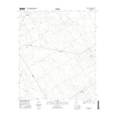
2016 Map of Westphalia
USGS Topo · Published 2016About this map
Westphalia anchors the northern reaches of this Central Texas landscape, where the agricultural traditions of Falls County meet the boundaries of Bell and Milam. The map reveals a rural network defined by family-named water bodies and small communities like Barclay and the uniquely named Zipperlandville. The settlement pattern is deeply rooted in the local geography, with drainage systems like Little Pond Cr and Keys Cr carving through the terrain towards Dry Hollow. This 2016 survey captures the enduring presence of communal centers, specifically noted through various burial grounds including Saint Marys Cem and Saint Joseph Cem. The presence of several private impoundments, such as Krause Lake and Smith Lake, alongside numerous country roads, suggests a landscape that remains focused on ranching and seasonal agriculture while preserving the spatial layout of earlier Texas farmsteads.
Find a feature on this map
62 named features on this map. Tap any name to fly to it.
Don’t see what you’re looking for? This feature index may not catch every label — zoom into the map to look around manually.
Map Details
Editions of this 2016 Westphalia Map
This is the sole edition of this map. No revisions or reprints were ever made.
Other maps of this area

1885 · Taylor
USGS Topo · 1:125,000

1887 · Taylor
USGS Topo · 1:125,000

1892 · Temple
USGS Topo · 1:125,000

1894 · Taylor
USGS Topo · 1:125,000

1954 · Waco
USGS Topo · 1:250,000

1954 · Austin
USGS Topo · 1:250,000

1955 · Waco
USGS Topo · 1:250,000

1962 · Rosebud
USGS Topo · 1:24,000
1962 · Ben Arnold
USGS Topo · 1:24,000

1962 · Cedar Springs
USGS Topo · 1:24,000