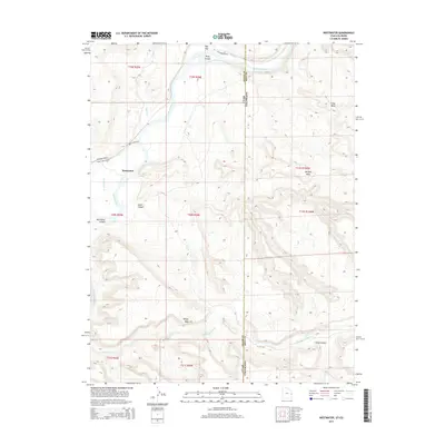
2014 Map of Westwater
USGS Topo · Published 2014About this map
The Colorado River carves through the heart of this high-desert landscape on the border of Grand County, Utah, and Mesa County, Colorado. The settlement of Westwater sits at a critical bend in the river, serving as a gateway to the dramatic river geography of Westwater Canyon and Ruby Canyon. This 2014 survey documents the complex drainage network of the region, where the Little Dolores River joins from the east and Bitter Cr flows from the north. The terrain is defined by a series of prominent elevated formations, including Snyder Mesa, Wrigley Mesa, and Long Mesa, which dictate the sparse road network. Access to the water is notably marked by Boat Launch Rd, reflecting the river's role as a primary corridor through this otherwise formidable canyon country. Farther south, the geography transitions toward Kings Canyon, illustrating the transition from open mesas to deep river-carved drainages.
Find a feature on this map
26 named features on this map. Tap any name to fly to it.
Don’t see what you’re looking for? This feature index may not catch every label — zoom into the map to look around manually.
Map Details
Editions of this 2014 Westwater Map
This is the sole edition of this map. No revisions or reprints were ever made.
Other maps of this area

1885 · East Tavaputs
USGS Topo · 1:250,000

1885 · La Sal
USGS Topo · 1:250,000

1954 · Westwater 4 SW
USGS Topo · 1:24,000

1954 · Mt. Waas 1 NE
USGS Topo · 1:24,000

1954 · Mt. Waas 1 NW
USGS Topo · 1:24,000

1954 · Coates Creek
USGS Topo · 1:62,500

1956 · Westwater 4 SE
USGS Topo · 1:24,000

1956 · Moab
USGS Topo · 1:250,000

1956 · Grand Junction
USGS Topo · 1:250,000

1959 · Grand Junction
USGS Topo · 1:250,000