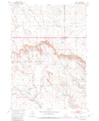
1950 Map of Weta
USGS Topo · Published 1980About this map
The settlement of Weta serves as a small rail-side hub within the sprawling landscape of Jackson County, South Dakota, situated along the tracks of the Chicago Milwaukee St Paul and Pacific. This 1950 survey, updated with revisions from the late 1970s, illustrates a stark and dramatic transition between the flat upland plains and the complex, eroded topography of the Buffalo Gap National Grassland. The map reveals a remote ranching and transit landscape, where travel is dictated by natural breaks in the terrain such as Chamberlain Pass and Hughes Pass. Scattered landmarks like the Peterson Ranch and the junction at Sevenmile Corner provide reference points in this sparsely populated territory. Water resources are primarily represented by the seasonal drainages of Little Buffalo Creek and Fifteenmile Creek, which carve deep patterns into the earth, highlighting the environmental challenges of mid-century life in the Great Plains.
Find a feature on this map
14 named features on this map. Tap any name to fly to it.
Don’t see what you’re looking for? This feature index may not catch every label — zoom into the map to look around manually.
Map Details
Editions of this 1950 Weta Map
2 editions found
Other maps of this area

1950 · Weta
USGS Topo · 1:24,000

1951 · Wanblee NW
USGS Topo · 1:24,000

1951 · School Section Butte
USGS Topo · 1:24,000

1951 · Kadoka
USGS Topo · 1:24,000

1951 · Wanblee NE
USGS Topo · 1:24,000

1953 · Philip Junction
USGS Topo · 1:24,000

1954 · Kadoka NE
USGS Topo · 1:24,000

1955 · Martin
USGS Topo · 1:250,000

1958 · Martin
USGS Topo · 1:250,000

1961 · Cottonwood NE
USGS Topo · 1:24,000