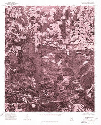
1975 Map of Wetumpka SE
USGS Topo · Published 1977About this map
Claud and Good Hope occupy a landscape of dense woodlands and cleared agricultural tracts in Elmore County during the mid-1970s. This orthophotoquad, produced from aerial photography taken in December 1975, offers a starkly different perspective than traditional line maps by showing the actual texture of the Alabama terrain. The image reveals a complex network of rural roads winding through the timber and farm fields, illustrating the dispersed settlement patterns typical of this region. By focusing on these photographic details, researchers can identify the specific footprints of farmsteads and the clear-cut boundaries between private property and forested creek bottoms. The contrast between the open pastures around the community of Claud and the more heavily wooded areas to the south provides a clear record of land use and rural development before modern suburban expansion.
Find a feature on this map
2 named features on this map. Tap any name to fly to it.
Don’t see what you’re looking for? This feature index may not catch every label — zoom into the map to look around manually.
Map Details
Editions of this 1975 Wetumpka SE Map
This is the sole edition of this map. No revisions or reprints were ever made.
Other maps of this area

1901 · Wetumpka
USGS Topo · 1:125,000

1901 · Wetumpka
USGS Topo · 1:62,500

1903 · Wetumpka
USGS Topo · 1:125,000

1906 · Dadeville
USGS Topo · 1:125,000

1953 · Montgomery
USGS Topo · 1:250,000

1955 · Phenix City
USGS Topo · 1:250,000

1956 · Montgomery
USGS Topo · 1:250,000

1957 · Phenix City
USGS Topo · 1:250,000

1957 · Montgomery
USGS Topo · 1:250,000

1958 · Phenix City
USGS Topo · 1:250,000