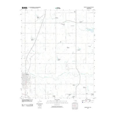
2010 Map of Wewoka East
USGS Topo · Published 2010About this map
Wewoka marks the western edge of this landscape, where the street grid transitions into a vast network of section roads and small-scale water management projects. The area is defined by the winding course of Wewoka Creek and its tributaries, including Tiger Creek, Jacobs Creek, and Long George Creek. The map reveals a high density of small earthen dams and reservoirs, often bearing family or local names such as Stafford and Jennings Dam, Grant Osborn Dam, Ralph Steele Dam, and Joe Greenlee Dam. These features suggest a landscape heavily modified for local agriculture and water storage in the early 21st century.
Find a feature on this map
36 named features on this map. Tap any name to fly to it.
Don’t see what you’re looking for? This feature index may not catch every label — zoom into the map to look around manually.
Map Details
Editions of this 2010 Wewoka East Map
This is the sole edition of this map. No revisions or reprints were ever made.
Other maps of this area

1896 · Seminole and Prague
USGS Topo · 1:125,000

1900 · Wewoka
USGS Topo · 1:125,000

1954 · Oklahoma City
USGS Topo · 1:250,000

1957 · Oklahoma City
USGS Topo · 1:250,000

1963 · Oklahoma City
USGS Topo · 1:250,000

1967 · Cromwell
USGS Topo · 1:24,000

1967 · Okemah SE
USGS Topo · 1:24,000

1967 · Prague SE
USGS Topo · 1:24,000
1972 · Wewoka West
USGS Topo · 1:24,000
1972 · Wewoka East
USGS Topo · 1:24,000