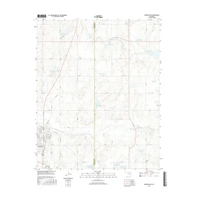
2016 Map of Wewoka East
USGS Topo · Published 2016About this map
The town of Wewoka serves as the focal point of this 2016 survey, situated along the western edge where the street grid transitions into the rural landscape of Seminole County and Hughes County. This region is characterized by a dense network of water management features, including the Big Wewoka Creek Site 32 Reservoir and the Stafford and Jennings Reservoir. These modern reservoirs, alongside the winding paths of Wewoka Creek and Long George Creek, illustrate the complex relationship between agricultural drainage and local topography.
Find a feature on this map
58 named features on this map. Tap any name to fly to it.
Don’t see what you’re looking for? This feature index may not catch every label — zoom into the map to look around manually.
Map Details
Editions of this 2016 Wewoka East Map
This is the sole edition of this map. No revisions or reprints were ever made.
Other maps of this area

1896 · Seminole and Prague
USGS Topo · 1:125,000

1900 · Wewoka
USGS Topo · 1:125,000

1954 · Oklahoma City
USGS Topo · 1:250,000

1957 · Oklahoma City
USGS Topo · 1:250,000

1963 · Oklahoma City
USGS Topo · 1:250,000

1967 · Cromwell
USGS Topo · 1:24,000

1967 · Okemah SE
USGS Topo · 1:24,000

1967 · Prague SE
USGS Topo · 1:24,000
1972 · Wewoka West
USGS Topo · 1:24,000
1972 · Wewoka East
USGS Topo · 1:24,000