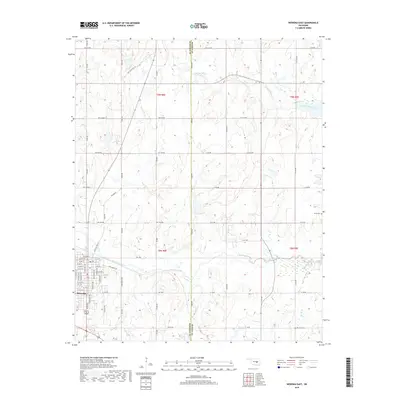
2018 Map of Wewoka East
USGS Topo · Published 2018About this map
Wewoka marks the southwestern boundary of this survey, where the town's street grid, including W Cedar St and E 14th St, meets the drainage of Wewoka Creek. The landscape transition here is defined by the Seminole Co / Hughes Co line, which cuts vertically through the center of the quadrangle. Most of the terrain is a network of watercourses, including Jacobs Cr and Tiger Cr, flowing between rolling sections of pasture and woodland. Genealogists and local historians will find several rural landmarks of interest, such as the Harjo Cem on the eastern edge and the McCaybe Cem further south. The transportation network is a mix of established routes like Old State Hwy 56 and more rural paths like Jack Rabbit Rd, reflecting the area's ongoing agricultural and residential character.
Find a feature on this map
72 named features on this map. Tap any name to fly to it.
Don’t see what you’re looking for? This feature index may not catch every label — zoom into the map to look around manually.
Map Details
Editions of this 2018 Wewoka East Map
This is the sole edition of this map. No revisions or reprints were ever made.
Other maps of this area

1896 · Seminole and Prague
USGS Topo · 1:125,000

1900 · Wewoka
USGS Topo · 1:125,000

1954 · Oklahoma City
USGS Topo · 1:250,000

1957 · Oklahoma City
USGS Topo · 1:250,000

1963 · Oklahoma City
USGS Topo · 1:250,000

1967 · Cromwell
USGS Topo · 1:24,000

1967 · Okemah SE
USGS Topo · 1:24,000

1967 · Prague SE
USGS Topo · 1:24,000
1972 · Wewoka West
USGS Topo · 1:24,000
1972 · Wewoka East
USGS Topo · 1:24,000