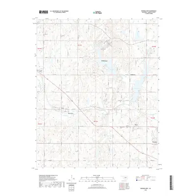
2018 Map of Wewoka West
USGS Topo · Published 2018About this map
Wewoka Lake and the smaller Sportsman Lake characterize this portion of Seminole County, where numerous small communities and rural cemeteries reflect a deep-rooted local history. The township is dotted with settlements such as Lima, New Lima, and Dixon, linked by a grid of rural roads like Ew 1270 RD and Lake Rd. This area is notable for its concentration of family and community burial sites, including Lima Cem, Scipio Cem, and Westwood Cem, which serve as vital markers for genealogists and local historians. The drainage of Wewoka Cr and Coon Creek shapes the topography, with Danielson Lake providing another significant water feature in the northern sections. This survey provides a clear view of the transition between small town centers and the surrounding agricultural and wooded landscape near Wewoka.
Find a feature on this map
45 named features on this map. Tap any name to fly to it.
Don’t see what you’re looking for? This feature index may not catch every label — zoom into the map to look around manually.
Map Details
Editions of this 2018 Wewoka West Map
This is the sole edition of this map. No revisions or reprints were ever made.
Other maps of this area

1896 · Seminole and Prague
USGS Topo · 1:125,000

1900 · Wewoka
USGS Topo · 1:125,000

1954 · Oklahoma City
USGS Topo · 1:250,000

1957 · Oklahoma City
USGS Topo · 1:250,000

1963 · Oklahoma City
USGS Topo · 1:250,000

1967 · Cromwell
USGS Topo · 1:24,000

1967 · Prague SW
USGS Topo · 1:24,000

1967 · Prague SE
USGS Topo · 1:24,000
1972 · Seminole
USGS Topo · 1:24,000
1972 · Wewoka West
USGS Topo · 1:24,000