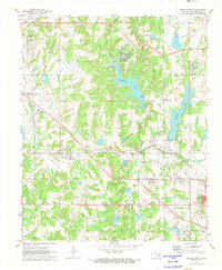
1972 Map of Wewoka West
USGS Topo · Published 1974About this map
Wewoka and its neighboring oil-rich landscapes are documented here in the early 1970s, showcasing a region defined by petroleum extraction and decentralized rural communities. Extensive oil fields and individual oil wells dot the terrain, particularly across Econtuchka and Lincoln townships, indicating the persistent industrial character of Seminole County. The Chicago Rock Island and Pacific railroad bisects the map, passing through the town of Lima and serving the heavy industry of the area.
Find a feature on this map
39 named features on this map. Tap any name to fly to it.
Don’t see what you’re looking for? This feature index may not catch every label — zoom into the map to look around manually.
Map Details
Editions of this 1972 Wewoka West Map
This is the sole edition of this map. No revisions or reprints were ever made.
Other maps of this area

1896 · Seminole and Prague
USGS Topo · 1:125,000

1900 · Wewoka
USGS Topo · 1:125,000

1954 · Oklahoma City
USGS Topo · 1:250,000

1957 · Oklahoma City
USGS Topo · 1:250,000

1963 · Oklahoma City
USGS Topo · 1:250,000

1967 · Cromwell
USGS Topo · 1:24,000

1967 · Prague SW
USGS Topo · 1:24,000

1967 · Prague SE
USGS Topo · 1:24,000
1972 · Seminole
USGS Topo · 1:24,000
1972 · Wewoka East
USGS Topo · 1:24,000