1963 Map of Wharncliffe
USGS Topo · Published 1966About this map
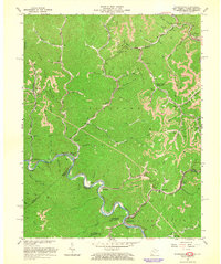
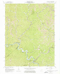
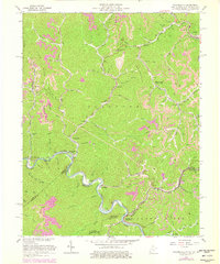
The Norfolk and Western railroad winds through the deep valleys of the Cumberland Plateau in this mid-century survey, following the sharp bends of the Tug Fork river. This watercourse serves as a critical boundary where the corners of West Virginia, Virginia, and Kentucky converge, linking coal-dependent settlements like Wharncliffe, War Eagle, and Alnwick. The landscape is heavily marked by the extractive industries of the era, shown through numerous Strip Mines, several Tipples, and a Compressor Station along the Magnolia Glen. Local life centers around small mountain gaps and hollows, where family-named landmarks and institutions like the Ben Creek Sch and Hardy Union Sch serve isolated communities. Notable post offices, including Wyoming City (Mohawk PO) and Gilbert Creek (Baisden PO), highlight the geographic importance of these rail-side junctions.
Find a feature on this map
67 named features on this map. Tap any name to fly to it.
Don’t see what you’re looking for? This feature index may not catch every label — zoom into the map to look around manually.
Map Details
Editions of this 1963 Wharncliffe Map
3 editions found
Other maps of this area

1886 · Grundy
USGS Topo · 1:125,000

1887 · Warfield
USGS Topo · 1:125,000

1890 · Grundy
USGS Topo · 1:125,000

1891 · Tazewell
USGS Topo · 1:125,000

1891 · Oceana
USGS Topo · 1:125,000

1891 · Warfield
USGS Topo · 1:125,000

1892 · Grundy
USGS Topo · 1:125,000

1893 · Oceana
USGS Topo · 1:125,000

1895 · Tazewell
USGS Topo · 1:125,000

1897 · Tazewell
USGS Topo · 1:125,000