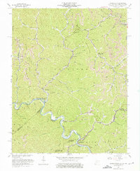
1963 Map of Wharncliffe
USGS Topo · Published 1976About this map
Tug Fork carves a winding path through the borderlands of West Virginia, Virginia, and Kentucky, anchoring a landscape shaped by coal extraction and rail transport. The Norfolk and Western railroad tracks follow the river's tight bends, serving a network of hollows where industrial and community life converged. Small settlements like Wharncliffe, War Eagle, and Glen Alum appear as essential hubs along the tracks, while higher elevations like Stafford Mountain and Magnolia Glen are marked by intensive Strip Mines. The geography of the early 1960s reveals how terrain dictated social structure, with schools like Cline Sch and Buchanan Sch situated near family-named landmarks like Twisted Gun Gap and Chestnut Log Hol. Cultural life is noted through numerous cemeteries and churches, including Wharncliffe Ch, scattered across the ridges and narrow valleys.
Find a feature on this map
77 named features on this map. Tap any name to fly to it.
Don’t see what you’re looking for? This feature index may not catch every label — zoom into the map to look around manually.
Map Details
Editions of this 1963 Wharncliffe Map
3 editions found
Other maps of this area

1886 · Grundy
USGS Topo · 1:125,000

1887 · Warfield
USGS Topo · 1:125,000

1890 · Grundy
USGS Topo · 1:125,000

1891 · Tazewell
USGS Topo · 1:125,000

1891 · Oceana
USGS Topo · 1:125,000

1891 · Warfield
USGS Topo · 1:125,000

1892 · Grundy
USGS Topo · 1:125,000

1893 · Oceana
USGS Topo · 1:125,000

1895 · Tazewell
USGS Topo · 1:125,000

1897 · Tazewell
USGS Topo · 1:125,000