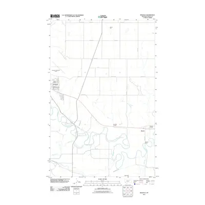
2011 Map of Whately
USGS Topo · Published 2011About this map
Milk River meanders through the heart of this Valley County landscape, defining the agricultural and transport corridors east of Glasgow. The 2011 survey captures the town's northern expansion, showing the Glasgow International Airport and the Glasgow Fire Dept North Side Fire Hall positioned near the residential streets of Highland Dr and Aberdeen St. This era reflects a highly managed water system essential for the region's ranching and farming, evidenced by the Vandalia South Canal and the Hanson Dam to the north.
Find a feature on this map
39 named features on this map. Tap any name to fly to it.
Don’t see what you’re looking for? This feature index may not catch every label — zoom into the map to look around manually.
Map Details
Editions of this 2011 Whately Map
This is the sole edition of this map. No revisions or reprints were ever made.
Other maps of this area

1914 · Nashua
USGS Topo · 1:62,500

1916 · Nashua
USGS Topo · 1:62,500

1918 · Porcupine Valley
USGS Topo · 1:62,500

1943 · Glasgow
USGS Topo · 1:125,000

1954 · Glasgow
USGS Topo · 1:250,000

1957 · Glasgow
USGS Topo · 1:250,000

1958 · Glasgow
USGS Topo · 1:250,000

1958 · Glasgow
USGS Topo · 1:24,000
1958 · Blanchard Ranch
USGS Topo · 1:24,000

1958 · Wheeler
USGS Topo · 1:24,000