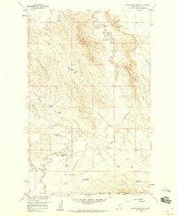
1958 Map of Blanchard Ranch
USGS Topo · Published 1960About this map
Blanchard Ranch and the nearby Archambeault Ranch anchor this landscape in the Missouri River Basin during the late 1950s. The terrain is defined by a sophisticated network of water management features, including the Retention Levees Experimental Area and numerous small reservoirs like Jack Rabbit Reservoir and Aitken Reservoir. This infrastructure suggests a period of intensive land use and agricultural experimentation within the Fort Peck Game Range. Drainage patterns are shaped by Willow Creek and Sage Hen Creek, which cut through the Flats toward the southern boundary. Small-scale industrial activity is evidenced by the Baldy Pit, while various gaging stations and retention structures like Archambeault Retention Res reflect a managed hydrologic environment typical of the era's conservation and ranching efforts.
Find a feature on this map
22 named features on this map. Tap any name to fly to it.
Don’t see what you’re looking for? This feature index may not catch every label — zoom into the map to look around manually.
Map Details
Editions of this 1958 Blanchard Ranch Map
2 editions found
Other maps of this area

1943 · Glasgow
USGS Topo · 1:125,000

1954 · Jordan
USGS Topo · 1:250,000

1954 · Glasgow
USGS Topo · 1:250,000

1956 · Jordan
USGS Topo · 1:250,000

1957 · Glasgow
USGS Topo · 1:250,000

1958 · Glasgow
USGS Topo · 1:250,000

1958 · Jordan
USGS Topo · 1:250,000

1958 · Engstrom Ranch
USGS Topo · 1:24,000

1958 · Miller Coulee
USGS Topo · 1:62,500

1958 · Collins Ranch
USGS Topo · 1:62,500