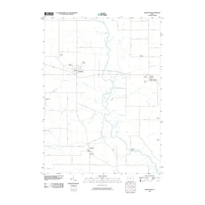
2010 Map of Wheatland
USGS Topo · Published 2010About this map
The Wapsipinicon River meanders through this portion of Clinton County, defining the agricultural landscape between the established communities of Wheatland and Calamus. In the early 21st century, the area maintains a high density of small rural burial grounds that speak to the long history of family farming and local parishes, such as Saint Pauls Cemetery and Homigrahusen Cemetery. The settlement at Big Rock sits near the southern edge of the quadrangle, connected to the larger towns by a grid of section-line roads like 210th St and 310th St. Waterways including Yankee Run and Calamus Creek feed into the Wapsipinicon, while landmarks like the High Rock Bridge and the Wheatland Post Office provide fixed points for local navigation and commerce in this quiet corner of Iowa.
Find a feature on this map
41 named features on this map. Tap any name to fly to it.
Don’t see what you’re looking for? This feature index may not catch every label — zoom into the map to look around manually.
Map Details
Editions of this 2010 Wheatland Map
This is the sole edition of this map. No revisions or reprints were ever made.
Other maps of this area

1890 · Durant
USGS Topo · 1:62,500

1891 · DeWitt
USGS Topo · 1:62,500

1891 · Davenport
USGS Topo · 1:62,500

1892 · Wheatland
USGS Topo · 1:62,500

1894 · Wheatland
USGS Topo · 1:62,500

1894 · Durant
USGS Topo · 1:62,500

1894 · Davenport
USGS Topo · 1:62,500

1901 · Rock Island
USGS Topo · 1:125,000

1910 · Rock Island
USGS Topo · 1:125,000
1953 · Donahue
USGS Topo · 1:24,000