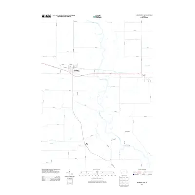
2013 Map of Wheatland
USGS Topo · Published 2013About this map
The Wapsipinicon River meanders through the heart of this East-Central Iowa landscape, defining the topography between the settlements of Wheatland and Calamus. The river's winding path is joined by numerous tributaries including Yankee Run, Lizard Cr, and Rock Cr, creating a complex network of wetlands and seasonal drainages. In Wheatland, the street grid centers on W Lincolnway St and Jefferson St, reflecting a traditional Midwestern rail-and-road layout.
Find a feature on this map
45 named features on this map. Tap any name to fly to it.
Don’t see what you’re looking for? This feature index may not catch every label — zoom into the map to look around manually.
Map Details
Editions of this 2013 Wheatland Map
This is the sole edition of this map. No revisions or reprints were ever made.
Other maps of this area

1890 · Durant
USGS Topo · 1:62,500

1891 · DeWitt
USGS Topo · 1:62,500

1891 · Davenport
USGS Topo · 1:62,500

1892 · Wheatland
USGS Topo · 1:62,500

1894 · Wheatland
USGS Topo · 1:62,500

1894 · Durant
USGS Topo · 1:62,500

1894 · Davenport
USGS Topo · 1:62,500

1901 · Rock Island
USGS Topo · 1:125,000

1910 · Rock Island
USGS Topo · 1:125,000
1953 · Donahue
USGS Topo · 1:24,000