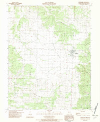
1982 Map of Wheatland
USGS Topo · Published 1982About this map
Wheatland serves as the central hub of this Hickory County landscape during the early 1980s, situated at the edge of the expansive Wheatland Prairie. The area is defined by its transition from the plateau into the winding river valleys, with the Pomme De Terre River and Pomme De Terre Lake anchoring the eastern and southern edges of the map. This survey is particularly valuable for genealogical research, documenting several family-named burial sites including Gentry Cem, Fairview-Butcher Cem, and Crutsinger Cem that dot the countryside.
Find a feature on this map
25 named features on this map. Tap any name to fly to it.
Don’t see what you’re looking for? This feature index may not catch every label — zoom into the map to look around manually.
Map Details
Editions of this 1982 Wheatland Map
This is the sole edition of this map. No revisions or reprints were ever made.
Other maps of this area

1884 · Bolivar
USGS Topo · 1:125,000

1886 · Stockton
USGS Topo · 1:125,000

1887 · Clinton
USGS Topo · 1:125,000

1887 · Warsaw
USGS Topo · 1:125,000

1892 · Bolivar
USGS Topo · 1:125,000

1894 · Warsaw
USGS Topo · 1:125,000

1894 · Clinton
USGS Topo · 1:125,000

1940 · Weaubleau
USGS Topo · 1:24,000
1940 · Iconium
USGS Topo · 1:24,000

1942 · Elkton
USGS Topo · 1:24,000