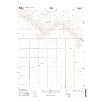
2017 Map of Wheatland
USGS Topo · Published 2017About this map
The settlement of Wheatland serves as the focal point for this 2017 survey on the High Plains, where the terrain transitions into a series of dramatic breaks and canyons. This landscape is defined by its verticality, with San Jon Hill overlooking a network of deep incisions including Tipton Canyon, Deadman Canyon, and Horseshoe Cave Canyon. The Wheatland Cemetery remains a significant marker of local history, situated just east of the main settlement. The geography is characterized by seasonal watercourses like the Arroyo Saladito and a rigid grid of roads that straddle the Quay County and Curry County line. These features suggest a ranching and farming economy shaped by the abrupt change from flat tablelands to the canyonlands of Grapevine Canyon in the southeast corner.
Find a feature on this map
25 named features on this map. Tap any name to fly to it.
Don’t see what you’re looking for? This feature index may not catch every label — zoom into the map to look around manually.
Map Details
Editions of this 2017 Wheatland Map
This is the sole edition of this map. No revisions or reprints were ever made.
Other maps of this area

1954 · Tucumcari
USGS Topo · 1:250,000

1954 · Clovis
USGS Topo · 1:250,000

1958 · Clovis
USGS Topo · 1:250,000

1958 · Tucumcari
USGS Topo · 1:250,000

1968 · Riley Camp
USGS Topo · 1:24,000

1968 · San Jon
USGS Topo · 1:24,000

1968 · Bedford Hill
USGS Topo · 1:24,000

1971 · Day Canyon
USGS Topo · 1:24,000
1971 · Apache Canyon
USGS Topo · 1:24,000

1971 · Wheatland
USGS Topo · 1:24,000