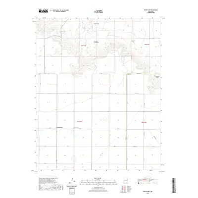
2020 Map of Wheatland
USGS Topo · Published 2020About this map
Wheatland serves as the primary landmark of this agricultural and high-plains landscape, situated just north of the Quay Co Curry Co boundary line. The settlement is anchored by the Wheatland Cem, reflecting the area's established local history and lineage. The northern portion of the map is defined by a dramatic transition from the plateau down through several named landforms, including San Jon Hill and a series of deep cuts such as Tipton Canyon and Horseshoe Cave Canyon. These features illustrate the drainage patterns of the region, where the Arroyo Saladito and other seasonal watercourses have carved into the escarpment. The section roads, labeled with both county systems such as Quay Rd and Curry Rd N, reveal a meticulously planned grid that supports the ranching and farming operations across this corner of New Mexico.
Find a feature on this map
28 named features on this map. Tap any name to fly to it.
Don’t see what you’re looking for? This feature index may not catch every label — zoom into the map to look around manually.
Map Details
Editions of this 2020 Wheatland Map
This is the sole edition of this map. No revisions or reprints were ever made.
Other maps of this area

1954 · Tucumcari
USGS Topo · 1:250,000

1954 · Clovis
USGS Topo · 1:250,000

1958 · Clovis
USGS Topo · 1:250,000

1958 · Tucumcari
USGS Topo · 1:250,000

1968 · Riley Camp
USGS Topo · 1:24,000

1968 · San Jon
USGS Topo · 1:24,000

1968 · Bedford Hill
USGS Topo · 1:24,000

1971 · Day Canyon
USGS Topo · 1:24,000
1971 · Apache Canyon
USGS Topo · 1:24,000

1971 · Wheatland
USGS Topo · 1:24,000