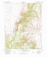
1952 Map of Wheelbarrow Peak
USGS Topo · Published 1985About this map
Wheelbarrow Peak stands as the prominent landmark of this high-desert territory within the Nellis Air Force Range, as it was surveyed in the early 1950s. The landscape is defined by its isolation and specialized land use, bounded by the Approximate Proving Ground Boundary. Sparse water sources like Indian Spr, Johnnies Water, and Sundown Reservoir highlight the arid nature of the Kawich Valley and surrounding slopes.
Find a feature on this map
26 named features on this map. Tap any name to fly to it.
Don’t see what you’re looking for? This feature index may not catch every label — zoom into the map to look around manually.
Map Details
Editions of this 1952 Wheelbarrow Peak Map
3 editions found

Other maps of this area

1908 · Kawich
USGS Topo · 1:250,000

1942 · Emigrant Valley
USGS Topo · 1:125,000

1942 · Reveille Peak
USGS Topo · 1:125,000

1942 · Wheelbarrow Peak
USGS Topo · 1:125,000

1942 · Penoyer Valley
USGS Topo · 1:125,000

1952 · Tippipah Spring
USGS Topo · 1:62,500

1952 · Quartzite Mtn
USGS Topo · 1:62,500

1952 · Papoose Lake
USGS Topo · 1:62,500

1952 · White Blotch Springs
USGS Topo · 1:62,500

1952 · Timber Mountain
USGS Topo · 1:62,500