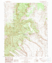
1988 Map of Wheelbarrow Peak
USGS Topo · Published 1988About this map
Wheelbarrow Range dominates this corner of Nye County, where the high-altitude terrain is shaped by the overlapping interests of federal land management and military defense in the late 1980s. The landscape is defined by the Nellis Air Force Range (Restricted Area) and the Nevada Wild Horse Management Area, reflecting a mid-century shift toward large-scale conservation and national security zones. Evidence of early prospectors remains at higher elevations, including a Mine Shaft and a Prospect located north of Wheelbarrow Peak. Despite the arid climate, isolated water sources such as Johnnies Water and Indian Spring provided critical hydration points in an otherwise daunting environment. This survey captures a moment when traditional ranching or mining access was superseded by more modern, restricted land uses.
Find a feature on this map
10 named features on this map. Tap any name to fly to it.
Don’t see what you’re looking for? This feature index may not catch every label — zoom into the map to look around manually.
Map Details
Editions of this 1988 Wheelbarrow Peak Map
This is the sole edition of this map. No revisions or reprints were ever made.
Other maps of this area

1908 · Kawich
USGS Topo · 1:250,000

1942 · Emigrant Valley
USGS Topo · 1:125,000

1942 · Reveille Peak
USGS Topo · 1:125,000

1942 · Wheelbarrow Peak
USGS Topo · 1:125,000

1942 · Penoyer Valley
USGS Topo · 1:125,000

1952 · White Blotch Springs
USGS Topo · 1:62,500

1952 · Wheelbarrow Peak
USGS Topo · 1:62,500

1952 · Belted Peak
USGS Topo · 1:62,500

1952 · Groom Mine
USGS Topo · 1:62,500

1954 · Caliente
USGS Topo · 1:250,000