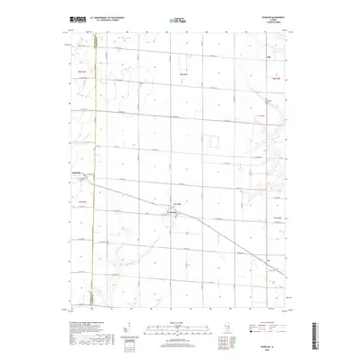
2018 Map of Wheeler
USGS Topo · Published 2018About this map
Wheeler and the surrounding prairie of eastern Illinois are defined by a regular grid of county roads and several small agricultural hubs along the rail line. Located near the Effingham and Jasper county line, the village of Dieterich sits in the west, home to the Immaculate Conception Cem. The landscape is etched by several drainage systems, most notably Big Muddy Cr, which wanders through the southern half of the quadrangle. Genealogists will find several burial grounds across the townships, including the Wheeler Cem, Brewer Cem, and Fairfield Cem near the northern boundary. Smaller settlements such as Gila and Lis anchor the eastern portions of the map, while the Rocky Ford Sportsman Club South Lake offers a localized water feature amidst the expansive fields. The placement of these cemeteries and hamlets illustrates the early 20th-century settlement patterns of these rural townships.
Find a feature on this map
47 named features on this map. Tap any name to fly to it.
Don’t see what you’re looking for? This feature index may not catch every label — zoom into the map to look around manually.
Map Details
Editions of this 2018 Wheeler Map
This is the sole edition of this map. No revisions or reprints were ever made.
Other maps of this area

1940 · Greenup
USGS Topo · 1:62,500

1941 · Newton
USGS Topo · 1:62,500

1943 · Greenup
USGS Topo · 1:62,500

1943 · Newton
USGS Topo · 1:62,500

1953 · Teutopolis
USGS Topo · 1:62,500

1953 · Sailor Springs
USGS Topo · 1:62,500

1958 · Decatur
USGS Topo · 1:250,000

1958 · Belleville
USGS Topo · 1:250,000

1961 · Decatur
USGS Topo · 1:250,000

1962 · Belleville
USGS Topo · 1:250,000