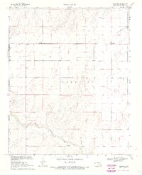
1969 Map of Wheeless
USGS Topo · Published 1971About this map
Mexhoma and Wheeless anchor this high plains landscape at the far western edge of the Oklahoma Panhandle during the late 1960s. The border between New Mexico and Oklahoma is clearly delineated, alongside the intersection of Union and Cimarron counties. This survey is notable for its depiction of the early North Canadian River as it meanders through the southern portion of the quadrangle. Local landmarks important for genealogy and land history include a small Church at Mexhoma and a lone Grave in the southeast. An old Trail is visible in the northeast corner, reflecting the historic transit routes across this arid terrain. The map also records several water sources critical for ranching, simply labeled as Well and Wells, highlighting the essential infrastructure for life in this part of the Cimarron valley.
Find a feature on this map
12 named features on this map. Tap any name to fly to it.
Don’t see what you’re looking for? This feature index may not catch every label — zoom into the map to look around manually.
Map Details
Editions of this 1969 Wheeless Map
2 editions found
Other maps of this area

1954 · Dalhart
USGS Topo · 1:250,000

1958 · Dalhart
USGS Topo · 1:250,000

1962 · Dalhart
USGS Topo · 1:250,000

1969 · Felt SW
USGS Topo · 1:24,000

1969 · Wheeless
USGS Topo · 1:24,000

1969 · Felt
USGS Topo · 1:24,000

1969 · Felt NE
USGS Topo · 1:24,000

1969 · Kenton SE
USGS Topo · 1:24,000
1969 · Kenton SW
USGS Topo · 1:24,000

1972 · Rardin Hill
USGS Topo · 1:24,000