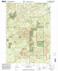
1997 Map of Whetstone Point
USGS Topo · Published 2000About this map
Bald Mountain and the high ridges of the Rogue River National Forest define this 1990s landscape in Jackson County. The map documents a blend of remote habitations and Forest Service infrastructure, including family-named sites like the Ash Homestead and Larsen Place alongside the Mathews Guard Station. High-elevation observation points at Halls Point Lookout and White Point Lookout oversee a terrain marked by deep drainage systems like Bitter Creek and Brush Creek. Resource extraction and wilderness management are visible in the proximity of the Al Serena Buzzard Mine to recreational and shelter sites such as Lusty Cabin and Little Bear Camp. The presence of Applegate Ford and Woodruff Bridge indicates critical crossing points where early travel routes met the region's waterways.
Find a feature on this map
54 named features on this map. Tap any name to fly to it.
Don’t see what you’re looking for? This feature index may not catch every label — zoom into the map to look around manually.
Map Details
Editions of this 1997 Whetstone Point Map
This is the sole edition of this map. No revisions or reprints were ever made.
Other maps of this area

1891 · Ashland
USGS Topo · 1:250,000

1893 · Ashland
USGS Topo · 1:250,000

1897 · Ashland
USGS Topo · 1:250,000

1944 · Abbott Butte
USGS Topo · 1:62,500

1947 · Abbott Butte
USGS Topo · 1:62,500

1954 · Butte Falls
USGS Topo · 1:62,500

1955 · Rustler Peak
USGS Topo · 1:62,500

1955 · Medford
USGS Topo · 1:250,000

1956 · Prospect
USGS Topo · 1:62,500

1957 · Medford
USGS Topo · 1:250,000