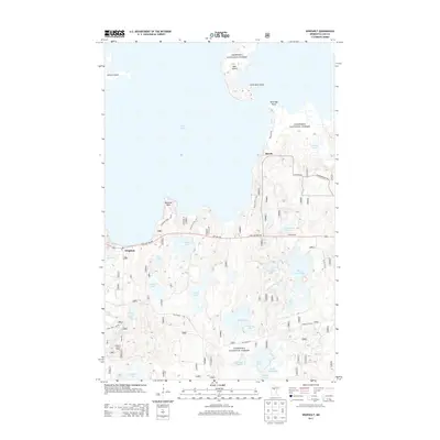
2013 Map of Whipholt
USGS Topo · Published 2013About this map
Leech Lake defines the northern reaches of this landscape, its expansive shoreline dotted with points and islands such as Diamond Point, Pelican Island, and Bear Island. Located within the Chippewa National Forest, the region is characterized by a dense network of smaller inland water bodies, including Three Island Lake, Gooseberry Lake, and Moccasin Lake. The small settlement of Whipholt sits along State Hwy 200 NW, serving as a focal point near the lake's edge with its post office and the nearby Whipholt Lookout Tower. To the northeast, the community of Brevik occupies a narrow peninsula near Partridge Point. The road system, featuring routes like Old Grade Rd and Tower Rd, reflects a landscape managed for timber and recreation, with numerous forest routes winding through the varied terrain of the national forest.
Find a feature on this map
45 named features on this map. Tap any name to fly to it.
Don’t see what you’re looking for? This feature index may not catch every label — zoom into the map to look around manually.
Map Details
Editions of this 2013 Whipholt Map
This is the sole edition of this map. No revisions or reprints were ever made.
Other maps of this area

1953 · Brainerd
USGS Topo · 1:250,000

1954 · Bemidji
USGS Topo · 1:250,000

1957 · Brainerd
USGS Topo · 1:250,000

1957 · Bemidji
USGS Topo · 1:250,000

1958 · Bemidji
USGS Topo · 1:250,000

1958 · Brainerd
USGS Topo · 1:250,000

1965 · Brainerd
USGS Topo · 1:250,000

1970 · Webb Lake
USGS Topo · 1:24,000

1970 · Woman Lake
USGS Topo · 1:24,000
1971 · Longville
USGS Topo · 1:24,000