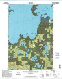
1996 Map of Whipholt
USGS Topo · Published 1998About this map
The southern waters of Leech Lake dominate this mid-1990s survey, illustrating the complex shoreline of the Leech Lake Indian Reservation. Within the protected boundaries of the Chippewa National Forest, the landscape is defined by a dense network of smaller inland water bodies like Moccasin Lake, Silver Lake, and Island Lake. The small settlements of Whipholt and Brevik serve as points of human presence along the coast, where numerous boat ramps and access points indicate the importance of the water to the local economy and recreation. The mapping of Pelican Island and Bear Island in Headquarters Bay provides a detailed look at the aquatic geography of the region before modern digital updates. This document, revised by the Forest Service, tracks the land use patterns and forest management tracts that characterize this portion of Cass County.
Find a feature on this map
30 named features on this map. Tap any name to fly to it.
Don’t see what you’re looking for? This feature index may not catch every label — zoom into the map to look around manually.
Map Details
Editions of this 1996 Whipholt Map
This is the sole edition of this map. No revisions or reprints were ever made.
Other maps of this area

1953 · Brainerd
USGS Topo · 1:250,000

1954 · Bemidji
USGS Topo · 1:250,000

1957 · Brainerd
USGS Topo · 1:250,000

1957 · Bemidji
USGS Topo · 1:250,000

1958 · Bemidji
USGS Topo · 1:250,000

1958 · Brainerd
USGS Topo · 1:250,000

1965 · Brainerd
USGS Topo · 1:250,000

1970 · Webb Lake
USGS Topo · 1:24,000

1970 · Woman Lake
USGS Topo · 1:24,000
1971 · Longville
USGS Topo · 1:24,000