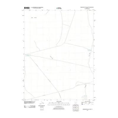
2011 Map of Whirlwind Valley SW
USGS Topo · Published 2011About this map
Swasey Mountain looms over this arid portion of Millard County, defining the western edge of a landscape shaped by intermittent water sources and high-desert infrastructure. The map documents a network of essential water points for ranching and wildlife, including Antelope Spring Reservoir, Soap Hollow Reservoir, and the seasonally variable Rain Lakes. These features are connected by established backcountry routes such as Death Canyon Rd and the historic alignment of Old 6 and 50, which transect the valley floor. The convergence of Tin Well Wash and Tin Well in the southeast corner further illustrates the importance of mapping every available water source in this desert terrain. The presence of Coyote Knolls and the drainage of Soap Hollow reveal a topography of subtle elevation changes that directed the placement of the area's few, isolated roads.
Find a feature on this map
11 named features on this map. Tap any name to fly to it.
Don’t see what you’re looking for? This feature index may not catch every label — zoom into the map to look around manually.
Map Details
Editions of this 2011 Whirlwind Valley SW Map
This is the sole edition of this map. No revisions or reprints were ever made.
Other maps of this area

1908 · Fish Springs
USGS Topo · 1:250,000

1910 · Fish Springs
USGS Topo · 1:250,000

1953 · Delta
USGS Topo · 1:250,000

1958 · Delta
USGS Topo · 1:250,000

1960 · Notch Peak
USGS Topo · 1:62,500

1962 · Delta
USGS Topo · 1:250,000

1972 · Whirlwind Valley SW
USGS Topo · 1:24,000
1972 · Long Ridge
USGS Topo · 1:24,000

1972 · Long Ridge Reservoir
USGS Topo · 1:24,000
1972 · Swasey Peak
USGS Topo · 1:24,000