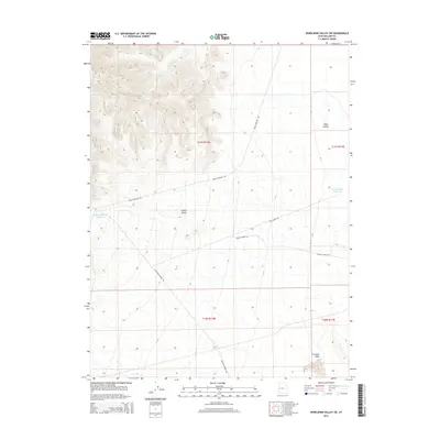
2014 Map of Whirlwind Valley SW
USGS Topo · Published 2014About this map
Coyote Knolls and the surrounding desert terrain define this corner of Millard County, where water management is central to the landscape. Modern livestock or land management infrastructure is evident through features like Antelope Spring Reservoir, Soap Hollow Reservoir, and the seasonally appearing Rain Lakes. The network of unpaved corridors, including Swasey Bottom Rd and Antelope Springs Rd, provides the primary access through this arid environment, connecting topographic landmarks like Soap Hollow and the drainage of Tin Well Wash. The map reflects a remote western landscape organized by the Public Land Survey System, with the terrain falling within t17s r12w and adjacent townships, illustrating the vast open spaces of the Great Basin.
Find a feature on this map
14 named features on this map. Tap any name to fly to it.
Don’t see what you’re looking for? This feature index may not catch every label — zoom into the map to look around manually.
Map Details
Editions of this 2014 Whirlwind Valley SW Map
This is the sole edition of this map. No revisions or reprints were ever made.
Other maps of this area

1908 · Fish Springs
USGS Topo · 1:250,000

1910 · Fish Springs
USGS Topo · 1:250,000

1953 · Delta
USGS Topo · 1:250,000

1958 · Delta
USGS Topo · 1:250,000

1960 · Notch Peak
USGS Topo · 1:62,500

1962 · Delta
USGS Topo · 1:250,000

1972 · Whirlwind Valley SW
USGS Topo · 1:24,000
1972 · Long Ridge
USGS Topo · 1:24,000

1972 · Long Ridge Reservoir
USGS Topo · 1:24,000
1972 · Swasey Peak
USGS Topo · 1:24,000