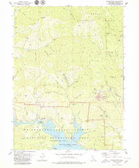
1979 Map of Whiskeytown
USGS Topo · Published 1979About this map
Whiskeytown Lake dominates the southern landscape of this California survey, reflecting the area's transformation within the Whiskeytown-Shasta-Trinity National Recreation Area. While the reservoir covers much of the historic valley floor, the surrounding hills of the Shasta National Forest are densely marked with evidence of an earlier industrial era. A significant concentration of mining activity is visible on Iron Mountain, where the Iron Mountain Mine, Richmond Mine, and extensive mine dumps appear alongside a tramway. This area is a complex network of resource extraction and modern water management, with numerous named gulches like Deadwood Gulch and Mad Mule Gulch feeding into the central basin. Remote outposts and infrastructure, such as the South Mtn Lookout and various radio facilities, overlook a terrain defined by both its gold-rush legacy and its mid-century development into a recreational hub.
Find a feature on this map
87 named features on this map. Tap any name to fly to it.
Don’t see what you’re looking for? This feature index may not catch every label — zoom into the map to look around manually.
Map Details
Editions of this 1979 Whiskeytown Map
This is the sole edition of this map. No revisions or reprints were ever made.
Other maps of this area

1890 · Red Bluff
USGS Topo · 1:250,000

1894 · Red Bluff
USGS Topo · 1:250,000

1901 · Redding
USGS Topo · 1:125,000

1913 · Weaverville
USGS Topo · 1:125,000

1944 · Redding
USGS Topo · 1:62,500

1944 · French Gulch
USGS Topo · 1:62,500

1946 · Lamoine
USGS Topo · 1:62,500

1946 · Redding
USGS Topo · 1:62,500

1948 · French Gulch
USGS Topo · 1:62,500

1950 · Schell Mtn
USGS Topo · 1:62,500