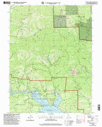
1998 Map of Whiskeytown
USGS Topo · Published 2003About this map
Whiskeytown Lake dominates the southern reaches of this landscape, a central feature of the Whiskeytown National Recreation Area. The surrounding terrain in the Shasta Trinity National Forests is heavily marked by industrial history, with numerous mines and prospects dotting the drainages of Clear Creek and its many tributaries. Notable operations such as the Gladstone Mine, Early Bird Mine, and Richmond Mine indicate the area's historical reliance on mineral extraction. In the southeast, Iron Mountain stands as a prominent landmark near the Mine Dump and Tailings areas, reflecting the scale of past earth-moving activities. Small settlements like Whiskeytown and Portuguese Flat are situated near the water's edge, while recreation sites like Oak Bottom Campground and the Whiskey Creek Picnic Area highlight the transition from an extractive economy to one centered on public land use and conservation.
Find a feature on this map
74 named features on this map. Tap any name to fly to it.
Don’t see what you’re looking for? This feature index may not catch every label — zoom into the map to look around manually.
Map Details
Editions of this 1998 Whiskeytown Map
This is the sole edition of this map. No revisions or reprints were ever made.
Other maps of this area

1890 · Red Bluff
USGS Topo · 1:250,000

1894 · Red Bluff
USGS Topo · 1:250,000

1901 · Redding
USGS Topo · 1:125,000

1913 · Weaverville
USGS Topo · 1:125,000

1944 · Redding
USGS Topo · 1:62,500

1944 · French Gulch
USGS Topo · 1:62,500

1946 · Lamoine
USGS Topo · 1:62,500

1946 · Redding
USGS Topo · 1:62,500

1948 · French Gulch
USGS Topo · 1:62,500

1950 · Schell Mtn
USGS Topo · 1:62,500