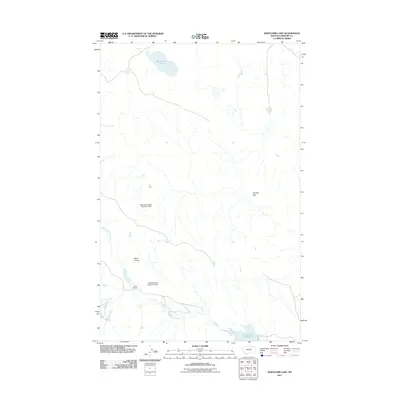
2011 Map of Whitcomb Lake
USGS Topo · Published 2011About this map
Whitcomb Lake sits at the northern end of this remote landscape in Phillips County, Montana. The terrain is defined by an intricate network of drainages and seasonal water features, including the Alkali Coulee and North Fork First Creek, which feed into the larger system of First Creek in the south. The area’s ranching economy is represented by established landholdings such as Cotter Ranch and infrastructure like the Veseth and Veseth Number 3 Dam and Blunt Ranches Number 4 Dam. These reservoirs and dams are essential for managing water across the arid stretches of The Big Sag, reflecting the logistical challenges of high-plains agriculture in the early 21st century. The map also shows the First Creek Reservoir, a primary catchment point that anchors the southeastern corner of the quadrangle.
Find a feature on this map
9 named features on this map. Tap any name to fly to it.
Don’t see what you’re looking for? This feature index may not catch every label — zoom into the map to look around manually.
Map Details
Editions of this 2011 Whitcomb Lake Map
This is the sole edition of this map. No revisions or reprints were ever made.
Other maps of this area

1954 · Jordan
USGS Topo · 1:250,000

1954 · Glasgow
USGS Topo · 1:250,000

1956 · Jordan
USGS Topo · 1:250,000

1957 · Glasgow
USGS Topo · 1:250,000

1958 · Glasgow
USGS Topo · 1:250,000

1958 · Jordan
USGS Topo · 1:250,000

1964 · Jordan
USGS Topo · 1:250,000

1965 · Sun Prairie
USGS Topo · 1:24,000

1965 · Whitcomb Lake
USGS Topo · 1:24,000
1965 · Stratton Reservoir
USGS Topo · 1:24,000