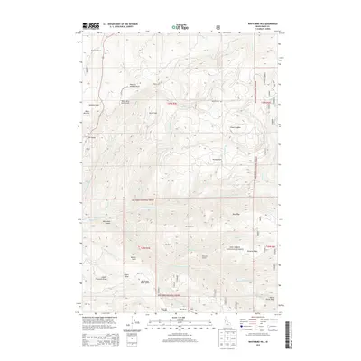
2013 Map of White Bird Hill
USGS Topo · Published 2013About this map
White Bird Hill Summit dominates this section of north-central Idaho, where the deep incisions of White Bird Canyon reveal the dramatic verticality of the landscape. The geography is defined by a dense network of drainage systems, including N Fork White Bird Cr and S Fork White Bird Cr, which have carved out prominent features such as Bentz Ridge and Pinnacle Ridge. These ridgelines and plateaus, like Service Flats and Burnt Flats, demonstrate the historical reliance on accessible high ground for movement before modern engineering.
Find a feature on this map
43 named features on this map. Tap any name to fly to it.
Don’t see what you’re looking for? This feature index may not catch every label — zoom into the map to look around manually.
Map Details
Editions of this 2013 White Bird Hill Map
This is the sole edition of this map. No revisions or reprints were ever made.
Other maps of this area

1955 · Grangeville
USGS Topo · 1:250,000

1959 · Grangeville
USGS Topo · 1:250,000

1963 · McKinzie Creek
USGS Topo · 1:24,000

1963 · Goodwin Meadows
USGS Topo · 1:24,000

1963 · Grangeville West
USGS Topo · 1:24,000

1963 · White Bird Hill
USGS Topo · 1:24,000

1963 · Slate Creek
USGS Topo · 1:24,000
1963 · Grangeville East
USGS Topo · 1:24,000
1963 · Dairy Mountain
USGS Topo · 1:24,000

1963 · White Bird
USGS Topo · 1:24,000