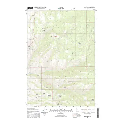
2017 Map of White Bird Hill
USGS Topo · Published 2017About this map
White Bird Hill and its dramatic surrounding topography dominate this Idaho County landscape within the Nez Perce National Forest. The map documents a complex network of historical and modern transportation routes, including Old Hwy 95 and the winding Old White Bird Hill Rd, which navigate the steep descent into White Bird Canyon. The drainage patterns are defined by the convergence of the N Fork White Bird Cr and S Fork White Bird Cr, carving deep draws such as Hernden Draw and Warden Gulch. High-elevation features like White Bird Hill Summit and Pinnacle Ridge overlook remote landing strips, including Wind Ridge Airport and Pinnacle Airport, illustrating the reliance on backcountry aviation in this isolated mountain terrain.
Find a feature on this map
46 named features on this map. Tap any name to fly to it.
Don’t see what you’re looking for? This feature index may not catch every label — zoom into the map to look around manually.
Map Details
Editions of this 2017 White Bird Hill Map
This is the sole edition of this map. No revisions or reprints were ever made.
Other maps of this area

1955 · Grangeville
USGS Topo · 1:250,000

1959 · Grangeville
USGS Topo · 1:250,000

1963 · McKinzie Creek
USGS Topo · 1:24,000

1963 · Goodwin Meadows
USGS Topo · 1:24,000

1963 · Grangeville West
USGS Topo · 1:24,000

1963 · White Bird Hill
USGS Topo · 1:24,000

1963 · Slate Creek
USGS Topo · 1:24,000
1963 · Grangeville East
USGS Topo · 1:24,000
1963 · Dairy Mountain
USGS Topo · 1:24,000

1963 · White Bird
USGS Topo · 1:24,000