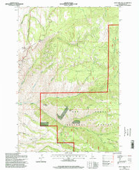
1995 Map of White Bird Hill
USGS Topo · Published 1999About this map
White Bird Hill dominates this portion of Idaho County, where the topography of the Nez Perce National Forest transitions from high ridges to deep drainage systems. Electronic sites and survey markers like the White Bird Hill Summit BM 4420 Electronic Site and Bald BM 4613 Electronic Site reflect the importance of high-altitude communication and surveying during the late twentieth century. Below these summits, the land is carved by an intricate network of waterways, including White Bird Creek, Cottonwood Creek, and Goose Creek. The presence of the Free Use Road and multiple Gravel Pits suggests ongoing local resource management and forest maintenance within the federal land. Family-named landmarks such as Harrison Johnson Draw and Jimmie Thompson Draw provide genealogical clues to early homesteaders and ranchers who navigated this steep landscape long before the 1995 survey update.
Find a feature on this map
37 named features on this map. Tap any name to fly to it.
Don’t see what you’re looking for? This feature index may not catch every label — zoom into the map to look around manually.
Map Details
Editions of this 1995 White Bird Hill Map
This is the sole edition of this map. No revisions or reprints were ever made.
Other maps of this area

1955 · Grangeville
USGS Topo · 1:250,000

1959 · Grangeville
USGS Topo · 1:250,000

1963 · McKinzie Creek
USGS Topo · 1:24,000

1963 · Goodwin Meadows
USGS Topo · 1:24,000

1963 · Grangeville West
USGS Topo · 1:24,000

1963 · White Bird Hill
USGS Topo · 1:24,000

1963 · Slate Creek
USGS Topo · 1:24,000
1963 · Grangeville East
USGS Topo · 1:24,000
1963 · Dairy Mountain
USGS Topo · 1:24,000

1963 · White Bird
USGS Topo · 1:24,000