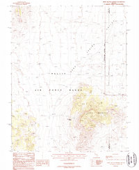
1988 Map of White Blotch Springs
USGS Topo · Published 1988About this map
White Blotch Springs and the surrounding high-desert terrain of the Nellis Air Force Range dominate this late-twentieth-century landscape. The map provides a look at the intersection of federal military lands and the traditional mining history of the Great Basin, evidenced by a Mine Shaft located west of the central mountain mass. Highlighting the stark geography of the Sand Spring Valley, the sheet captures a rugged expanse defined by Chalk Mountain and a strictly regulated Restricted Access Area. This 1980s documentation illustrates the modern administrative boundaries of the Nye and Lincoln County line as it cuts through the desert, showing how isolated geographic features like 4wd tracks served as the primary transit routes in this remote portion of Nevada.
Find a feature on this map
10 named features on this map. Tap any name to fly to it.
Don’t see what you’re looking for? This feature index may not catch every label — zoom into the map to look around manually.
Map Details
Editions of this 1988 White Blotch Springs Map
This is the sole edition of this map. No revisions or reprints were ever made.
Other maps of this area

1908 · Kawich
USGS Topo · 1:250,000

1942 · Emigrant Valley
USGS Topo · 1:125,000

1942 · Reveille Peak
USGS Topo · 1:125,000

1942 · Wheelbarrow Peak
USGS Topo · 1:125,000

1942 · Penoyer Valley
USGS Topo · 1:125,000

1952 · White Blotch Springs
USGS Topo · 1:62,500

1952 · Wheelbarrow Peak
USGS Topo · 1:62,500

1952 · Belted Peak
USGS Topo · 1:62,500

1952 · Groom Mine
USGS Topo · 1:62,500

1954 · Caliente
USGS Topo · 1:250,000