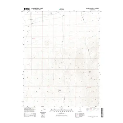
2015 Map of White Blotch Springs SE
USGS Topo · Published 2015About this map
Groom Range dominates the southeastern portion of this Lincoln County quadrangle, where the high desert terrain meets the open expanse of Sand Spring Valley to the north. This 2015 survey reveals a landscape largely defined by its isolation and its role within the restricted environments of southern Nevada. A sparse network of unpaved desert tracks, including Stewart Well Rd and Tickapoo Spring Rd, provides the only access through these high-altitude basins and range fronts. The infrastructure shown, such as Nellis Range Rd and Southwestern Pond Rd, reflects the area's proximity to military and government operations, documenting the specific transportation routes used for range management and resource monitoring in the early 21st century.
Find a feature on this map
12 named features on this map. Tap any name to fly to it.
Don’t see what you’re looking for? This feature index may not catch every label — zoom into the map to look around manually.
Map Details
Editions of this 2015 White Blotch Springs SE Map
This is the sole edition of this map. No revisions or reprints were ever made.
Other maps of this area

1942 · Emigrant Valley
USGS Topo · 1:125,000

1942 · Penoyer Valley
USGS Topo · 1:125,000

1952 · White Blotch Springs
USGS Topo · 1:62,500

1952 · Groom Mine
USGS Topo · 1:62,500

1954 · Caliente
USGS Topo · 1:250,000

1959 · Caliente
USGS Topo · 1:250,000

1964 · Tempiute Mtn
USGS Topo · 1:62,500

1985 · Pahranagat Range
USGS Topo · 1:100,000
1987 · Tempiute Mountain South
USGS Topo · 1:24,000
1987 · Tempiute Mountain North
USGS Topo · 1:24,000