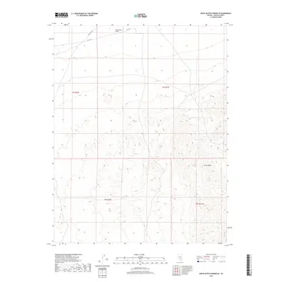
2018 Map of White Blotch Springs SE
USGS Topo · Published 2018About this map
Sand Spring Valley occupies the northern reaches of this Lincoln County landscape, transitioning into the high elevations of the Groom Range to the southeast. This 2018 survey documents a remote portion of the Great Basin where human infrastructure is limited to primitive travel ways such as Desert Dog Rd and Valley Rd. The map illustrates the complex topography of the range, with its intricate drainage patterns and sharp ridgelines, while the valley floor reflects the characteristic alluvial plains of the region. This document is essential for understanding the modern boundary configurations of Public Land Survey System townships, including t4s r54e and t5s r55.5e, in an area defined by its open terrain and lack of permanent settlements.
Find a feature on this map
8 named features on this map. Tap any name to fly to it.
Don’t see what you’re looking for? This feature index may not catch every label — zoom into the map to look around manually.
Map Details
Editions of this 2018 White Blotch Springs SE Map
This is the sole edition of this map. No revisions or reprints were ever made.
Other maps of this area

1942 · Emigrant Valley
USGS Topo · 1:125,000

1942 · Penoyer Valley
USGS Topo · 1:125,000

1952 · White Blotch Springs
USGS Topo · 1:62,500

1952 · Groom Mine
USGS Topo · 1:62,500

1954 · Caliente
USGS Topo · 1:250,000

1959 · Caliente
USGS Topo · 1:250,000

1964 · Tempiute Mtn
USGS Topo · 1:62,500

1985 · Pahranagat Range
USGS Topo · 1:100,000
1987 · Tempiute Mountain South
USGS Topo · 1:24,000
1987 · Tempiute Mountain North
USGS Topo · 1:24,000