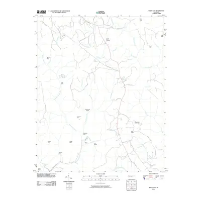
2010 Map of White City
USGS Topo · Published 2010About this map
Pryor Ridge and the Big Ridge dominate this Tennessee landscape, where the plateau is deeply dissected by drainage systems like Big Fiery Gizzard Creek and Little Gizzard Creek. The area retains evidence of its industrial and transit history, notably the Marshal Meeks Number 3 Mine located near Big Ridge, and the path of the Old Stage Coach Rd winding through the western coves. Local family names are etched into the geography at landmarks such as Gregg Cemetery and the Haskell Foster Lake Dam. The terrain is characterized by dramatic overlooks and recessed valleys, including Raven Point and Denny Cove, which reflect a rugged topographic character common to the Cumberland Plateau region. Water features like Foster Falls and Sawmill Creek further define the intricate network of the Tennessee watershed recorded in this survey.
Find a feature on this map
58 named features on this map. Tap any name to fly to it.
Don’t see what you’re looking for? This feature index may not catch every label — zoom into the map to look around manually.
Map Details
Editions of this 2010 White City Map
This is the sole edition of this map. No revisions or reprints were ever made.
Other maps of this area

1895 · Sewanee
USGS Topo · 1:125,000

1936 · Palmer
USGS Topo · 1:24,000

1936 · Orme
USGS Topo · 1:24,000

1936 · Whitwell
USGS Topo · 1:24,000

1936 · Burrow Cove
USGS Topo · 1:24,000

1936 · Tracy City
USGS Topo · 1:24,000

1936 · Monteagle
USGS Topo · 1:24,000

1936 · White City
USGS Topo · 1:24,000
1936 · Sequatchie
USGS Topo · 1:24,000
1936 · South Pittsburg
USGS Topo · 1:24,000