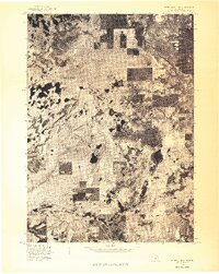
1976 Map of White Cloud NE
USGS Topo · Published 1976About this map
Brohman sits as a central point of reference in this mid-1970s orthophotoquad, which provides a high-altitude visual record of the Newaygo County landscape. Unlike a traditional line-and-symbol map, this aerial survey uses optical scanning of 1:80,000-scale photography to show the actual ground cover, revealing the dense patchwork of woodlots and open fields surrounding Woodland Park. The imagery captures the specific patterns of land use and vegetation during the spring of 1976, offering a unique perspective on the rural roads and natural clearings that defined the township before modern development or forest maturation altered the terrain. The presence of numerous small lakes and glacial depressions is clearly visible across the surface, providing a raw look at the hydrology of the White Cloud area.
Find a feature on this map
2 named features on this map. Tap any name to fly to it.
Don’t see what you’re looking for? This feature index may not catch every label — zoom into the map to look around manually.
Map Details
Editions of this 1976 White Cloud NE Map
This is the sole edition of this map. No revisions or reprints were ever made.
Other maps of this area

1954 · Midland
USGS Topo · 1:250,000

1958 · Midland
USGS Topo · 1:250,000

1958 · Woodville
USGS Topo · 1:62,500

1959 · Midland
USGS Topo · 1:250,000

1959 · Reed City
USGS Topo · 1:62,500

1959 · Baldwin
USGS Topo · 1:62,500

1959 · White Cloud
USGS Topo · 1:62,500

1966 · Midland
USGS Topo · 1:250,000
1976 · White Cloud SW
USGS Topo · 1:24,000
1976 · Baldwin SE
USGS Topo · 1:24,000